
Mapping the past: 300,000km of Roman roads charted in new digital project
Remember that viral TikTok trend which suggested most men think about the Roman empire several times a day?
We certainly do, and we're not alone it seems.
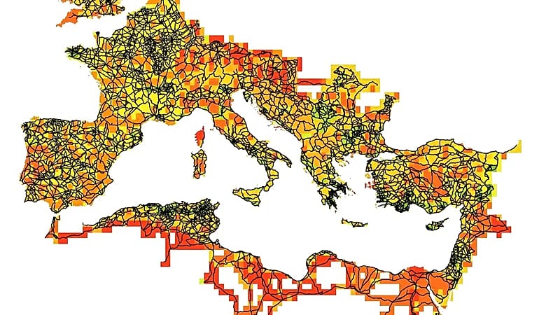
The Itiner-e project has achieved what seemed impossible: mapping with unprecedented precision 299,171 kilometres of Roman roads, almost double the 188,555 km collected by the most complete digital resources to date.
The result not only duplicates cartographic knowledge of Roman roads, but transforms our understanding of how the Roman Empire functioned: how legions moved, how goods travelled, how imperial orders were transmitted and, ultimately, how Rome built and maintained the greatest empire of antiquity for centuries.
This ambitious work, led by researchers from the Universitat Autònoma de Barcelona and Denmark's University of Aarhus, has been published in the journal 'Scientific Data' of the Nature group. It represents the most exhaustive synthesis of centuries of archaeological and historical research.
The dataset covers the Roman Empire at its greatest extent (around 150 AD), covering almost 4 million km² including Europe, North Africa and the Middle East.
What is truly revolutionary is that only 2.737% of these tracks have a certified spatial location, while 89.818% are conjectured and 7.445% are hypothetical. This revelation shows the huge gap between knowing that a road existed and knowing its exact layout.
How the most detailed map of Roman roads was made
The Itiner-e team used a three-phase methodology to build this digital atlas. First, they identified the roads through archaeological, historical and epigraphic sources: excavations, field studies, milestones (the Roman kilometre markers) and ancient documents such as the Antonine Itinerary and the Tabula Peutingeriana.
They also used the LIRE (Latin Inscriptions of the Roman Empire) database, which contains 8,388 milestones with Latin inscriptions.
Secondly, they spatially located these roads by comparing the information with modern and historical topographic maps, aerial photographs (including USAF missions from the 1950s), current satellite images and historical photographs from the Corona programme (1967-1972). The latter resource was critical for areas currently inundated by modern reservoirs.
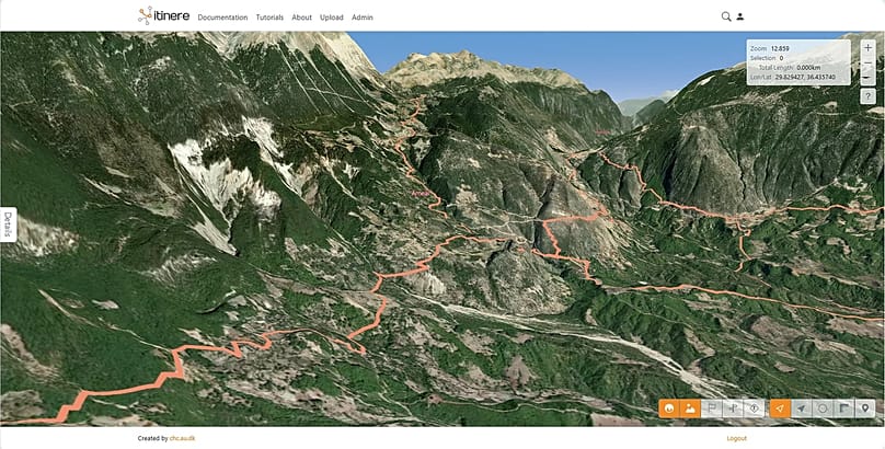
Finally, they manually digitised each section with a spatial resolution of between five and 200 metres, following the real terrain: winding mountain passes, valleys and natural corridors, rather than simple straight lines.
The result is 14,769 road segments organised in a two-level hierarchy:
- Main roads (103,477.9 km, 34.58% of the total) documented by milestones or historical sources, which structured the imperial administration and army.
- Secondary roads (195,693.3 km, 65.42%), revealing local and regional mobility.
The project has also generated confidence maps that visualise where data is lacking and where future research can concentrate on expanding the mapped routes.
A living resource for understanding the ancient world
"The extensive dataset generated by the Itiner-e project is highly transformative for understanding how the Roman road system structured the movement of people, goods, ideas and even disease in antiquity," explained project leaders Pau de Soto, Adam Pažout and Tom Brughmans.
The high resolution of the map enables new computational studies on connectivity, transport costs and administrative control, as well as research on the millennia-long development of land mobility.
The interdisciplinary, collaborative and open source nature of Itiner-e makes it a living platform. Researchers can incorporate new findings while maintaining authorship of their data, while the general public can access it free of charge via https://itiner-e.org.
Among the best documented regions are the Iberian Peninsula, Greece, North Africa, the Levant and Asia Minor, thanks to previous projects such as Mercator-e and Desert Networks.
The map also reveals significant gaps in current knowledge: areas with low data representativeness include northern England, Cornwall, the middle and upper Danube, Tuscany, Corsica and central Anatolia. These areas are priorities for future research campaigns.
In addition, the project has identified the North African deserts and mountainous areas as presenting the greatest documentation challenges.
The Itiner-e is the most complete digital map of the Roman road system to ever be created.
With almost 300,000 kilometres of documented roads, twice as many as previous resources, it reveals how the Empire moved its legions, how and where goods travelled and crucially points to how the Romans managed to retain power for centuries.