

Extreme weather: torrential rain and flooding in Liguria, Lombardy and Tuscany
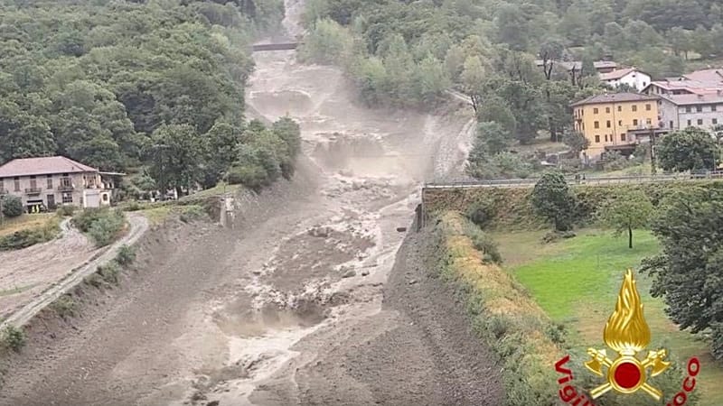
Within a matter of hours, the extreme heat that had been tormenting northern Italy for weeks gave way to exceptional rainfall, flooding and a sharp drop in temperatures. The regions hit hardest were Liguria, Lombardy and the northern part of Tuscany.
The disturbance that swept in was "fuelled" by a marine heatwave that pushed the Mediterranean above 33 degrees Celsius off the Spanish island of Majorca, according to data recorded by a buoy operated by the Aemet meteorological agency (source in Italian). When the first flow of cooler, more unstable air met the hot air masses lingering over northern regions, together with the humidity picked up from the sea, it triggered the first extreme events of the late-summer period.
In Liguria, 40,000 lightning strikes in 24 hours: train and Ventimiglia station hit, flooding in Tigullio
Liguria was the first to bear the brunt. According to the Civil Protection agency, around 40,000 lightning strikes hit the region. One of them, on the morning of Thursday 20 August, hit a Frecciabianca train that had left Genoa station bound for Rome, forcing the convoy to stop and passengers to disembark.
In the regional capital, the storms caused major damage above all to seaside bathing facilities, particularly in the stretch between Cogoleto and Arenzano, where cabins, sunbeds and parasols were swept away by the force of the wind.
Agriculture has also suffered heavy losses: the farmers' association Coldiretti has reported that in the Tigullio hinterland a situation described as "alarming" is emerging, especially for olive growing: "The picture that emerges is that of a year compromised for the olive harvest, and we are receiving reports of losses in the wine-growing sector as well."
Another lightning strike hit the railway traffic control centre at Ventimiglia station, in the western part of the region, forcing train services to be suspended.
Out at sea off the Tigullio coast, what meteorologists call a "supercell" formed, bringing extraordinary rainfall in just a few minutes. Within 24 hours, 200 millimetres of rain fell on Chiavari and Lavagna, while a waterspout developed off Rapallo. Numerous streets were flooded in all three municipalities, damaging infrastructure and shops. Trees also came down on the hills above Sestri Levante.
In northern Tuscany, more than 23,000 lightning strikes were recorded in total. The Lamma Consortium (Environmental Monitoring and Modelling Laboratory for Sustainable Development) explained that "in twelve hours, rainfall totals of 60–70 millimetres were recorded in the provinces of Massa Carrara, Lucca and Grosseto, and 40–50 mm in the provinces of Siena, Pisa and Livorno".
As for the winds, "gusts of up to 106 km/h were recorded on the Pisa coast, 103 km/h in the province of Florence, 93 km/h on Gorgona, 92 km/h in Viareggio and 86 km/h in the Arezzo area". In Grosseto, a tornado ripped off the roof of a building.
In Lombardy, torrential rain and 350 people evacuated
In Lombardy the areas worst affected were the provinces of Brescia, Sondrio and Bergamo. In Sonico, a debris flow from Val Rabbia carried water, boulders and rubble onto state road 42 to the Tonale Pass, causing a bridge to collapse. In the Bergamo area, around 350 people have been evacuated because of the extreme weather. On the Orobic Alps, near Lake Como, rainfall totals of up to 250 millimetres were recorded, according to the Lombardy regional hydrometeorological and climate centre at Arpa.
In Alta Val Brembana, also in the province of Bergamo, a slope collapsed along a provincial road, while falling trees damaged several parked cars. On the morning of Friday 21 August, six municipalities (Valleve, Carona, Foppolo, Branzi, Valbondione and Gandellino) were still cut off. Finally, a campsite at Isola di Fondra was evacuated because of the risk of a possible landslide.
The impact of climate change on extreme weather events
Although specific analyses (source in Italian) are needed to attribute any single weather event directly to global warming, scientists have been warning for decades that the rise in global average temperature caused by human activity, starting with the burning of coal, oil and gas, will increase the frequency, intensity and duration of extreme weather events.
Not only heatwaves, drought and wildfires like those that in recent weeks have affected France and Spain, but also exceptional rainfall and flooding, as seen in northern Italy in recent hours.
In Europe in particular, climate warming appears to be progressing faster than the global average, increasing the likelihood that such phenomena will occur. According to the European climate monitoring service Copernicus, the record for average temperature for the June–July period, set in 2022, has been broken this year because of the extreme heatwaves that have affected western Europe since the end of May, pushing the two-month average up to 21.62°C.
This text was translated with the help of artificial intelligence. Report a problem : [feedback-articles-en@euronews.com].
Today